YellowScan, Xer Technologies partner for underwater topography mapping
August 21, 2024
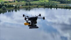
Xer Technologies and YellowScan have partnered to integrate the YellowScan Navigator bathymetric system into Xer Technologies’ UAVs.
Read More
Xer Technologies and YellowScan have partnered to integrate the YellowScan Navigator bathymetric system into Xer Technologies’ UAVs.

The University of Alabama, with the support of the National Science Foundation (NSF), has established a program unlike any other in the country. It focuses on positioning, navigation, timing, and frequency (PNTF) as its own discipline.
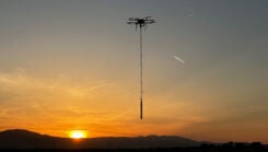
Skyfront has released the Skyfront MagniPhy, a UAV magnetometer designed for surveying, mineral prospecting, locating orphaned wellheads, and detecting landmines and unexploded ordnance (UXO).

FJDynamics has launched the FJD AT2 Max auto-steer system. It features enhanced hardware with a larger 12.1-inch display and a powerful CPU processor.
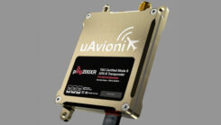
uAvionix’s ping200XR Mode S ADS-B transponder with integral aviation GPS has received technical standard order (TSO) certification from the FAA.

SandboxAQ has been awarded an SBIR Phase 2B Tactical Funding Increase (TACFI) by the United States Air Force (USAF) to further develop its dual-use AQNav magnetic navigation (MagNav) system.

The satellite Doppler positioning technique was pioneered in the early space age, using the Doppler frequency shift of satellite signals to determine receiver positions. This concept was first utilized by the U.S. Navy to develop the Transit navigation system.

To further enhance the benefits of combining space-based geodetic techniques, the European Space Agency (ESA) has established the Genesis mission.


Follow Us